Hazelbeach is a riverside village residing in the parish of Llanstadwell and it is sometimes thought, mistakely, that the village name is also Llanstadwell. The name has morphed from Hazzlebeach and has nothing to do with the Hazel tree. Although Richard Fenton in A Historical Tour Through Pembrokeshire (1818 pp 276) called it Hazelbitch

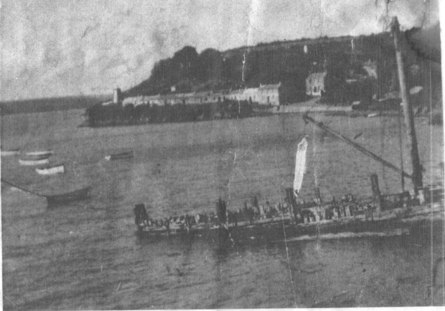
A view of the village taken from what is now the beer garden of the Ferry Inn. The Pier is already in a state if disrepair at this time. Originally this was a lane leading the lighthouse and there was a row of cottages where now stands the dining room the the Ferry Inn.
Evidence that the area has been inhabited since early times, was of some importance being worth defending, is supplied by name of some of the fields. Camp Park, a field in the north east of the parish near the boundary with Rosemarket has the scanty remains of a rath and there was another of which traces have completely disappeared although the field name Camp meadow might give some indication of the site as well might Mount Meadow. Lewis, In 1841, records that "some remains of two ancient British encampments, comprising each an area of about one acre, are visible; one is situated at the north-eastern extremity of the parish, nearly opposite the village of Rhosmarket (now Rosemarket), and the other at its south-western extremity, on a point on the shore of Milford Haven".
Taking the field names into consideration the old field names of Longstone, Longstone Park, Longstone Meadow near Waterston could indicate that in the long distant past that here could have been the site of a burial chamber but that all traces have been destroyed. There is one example in the next parish of Burton. Bronze age man also left his mark with a scattering of burnt mounds, low mounds of burnt cracked stone situated near a stream, the remains, it is presumed, of early to middle Bronze age cooking sites.
With the coming of Christianity to the area, the name Llanstadwell, a Celtic enclosure or church site (Llan) coupled with what would appear to be the name of the Saint to whom the church is dedicated (Tudwal), would suggest a very early Celtic Christian settlement. There have been questions raised about the name of the Saint as St Tudwal is more usually associated with Churches in the north of Wales. Certainly the settlement was one of importance with a ruling Welsh family or clas whose were direct descendants of Hywel Dda the last Welsh ruler of the whole of Wales and the great law giver with a palace at Whitland. A family whose descendants played a very important part in the life of Pembrokeshire and of medieval Britain.
Compared with many of the towns of the area Llanstadwell today appears insignificant but in 1578 it was important enough to appear on the first map of Pembrokeshire by Christopher Saxton who under the authority of Queen Elizabeth I, surveyed the whole of England and Wales. His map of Pembrokeshire is dated 1578 and both Llanstadwell and Newton appear on it. They both appear on Speede's map of 1610 and Llanstadwell is recorded on Capt. Collin's Navigational Chart of the Milford Haven compiled in the 1690's. Nayland, Llanstadwell and Newton are shown by Lewis Morris on his plan of Milford Haven published on the 29th September 1748.
According to a survey of Crown lands in 1623-4; it was apparent that the remnants of the old manorial system was still in existence in the area, with tenants farming several small pieces of land intermingled with that of their fellow tenants and at that time it was recommended that the various holdings should be consolidated so that the tenants could enclose them, but this process still had not been completed by the mid 1700's in Llanstadwell and not till the 1800's in Honeyborough.
Much of the modern expansion of the village is fuelled by money earned in the refining industry.
There used to be two shops and a Post Office in living memory. All have now disappeared with the buildings now used as residences.
Few of the people born there before the oil rush now life there, either having moved away for better jobs or expired of old age. A few still linger on as the only living repositories of the pre-oil memories of the village.
There is still a pub, although much altered from its Ferry House days and incorporating some of the houses of what used to be the street of Ferry Row. Of the lighthouse at the end of Ferry Row there is no sign.
The small housing estate of Lighthouse Drive is built upon fields that once contained another light house. You can clearly see the Ferry Row lighthouse in the image below and the lighthouse in what is now Lighthouse Drive.
Not strictly in Hazelbeach but definitely important and needs the recording of it's existence. The village of Newton no longer exists. Once the residence of Princes, now a forgotten place swept away in the quest for progress. Buried under an oil refinery thence to become Gas storage facility. Progress?
Newton was once the residence of the princely family of Craddock, linearly descended from Hywel Dda, Lords of this place, whose descendent Sir Richard married Emma, daughter and co-heiress of Sir Thomas Perrott of Eastington and dropped the name Craddock took the name of Newton, and was Chief Justice of Common Pleas. This led him to settle in England and dispose of his property in Wales. He died December the 14th 1444, and lies buried in a chapel on the south side of Bristol Cathedral" [1]. The site of village is now under the Dragon Gas storage facility.
If anyone wants to add/contribute, or use this content, please contact me. mike at hazelbeach.co.uk